
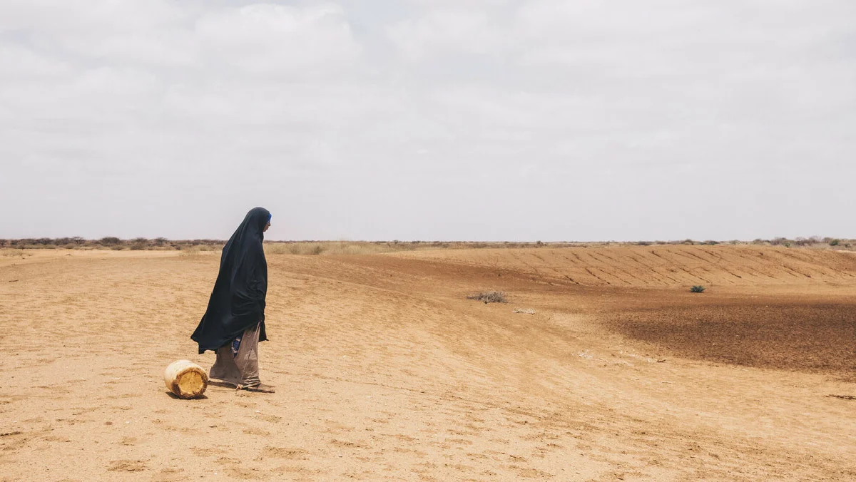
Sand dunes are pushing into villages and public facilities across Wajir County, choking roads, blocking water points and forcing costly clean-ups.
Local authorities and aid agencies describe a slow-moving emergency driven by recurrent droughts, vegetation loss and strong winds that whip up loose soils into migrating dunes, an “advancing desert” reshaping parts of Kenya’s north-east.
“Only Allah can truly help us; no one else can. From sunrise to sunset and through the night, the sand dunes keep advancing. We can’t even step out to get food. The constant dust gives us flu, allergies, and skin irritation,” said Mohamed Abdi, a resident of Athibohol in Wajir, speaking on NTV’s Earthwise program.
“Personally, I’ve grown this thin because of the dust, it’s day and night. Even what we eat doesn’t help the body anymore. The dust season starts now and continues until around August or September,” he added.
Wajir sits in Kenya’s arid and semi-arid belt, where rains are brief and erratic and ground cover is sparse for much of the year.
That makes surfaces highly erodible: once vegetation is stripped by drought, overgrazing, wood-fuel collection or invasive species, winds mobilise sand and fine dust that then creep and saltate across the landscape, building dunes and burying infrastructure.
The physical mechanics are well-established: low vegetation, dry soils and turbulent near-surface winds create ideal conditions for sand movement and dust storms.
Recent local reporting highlights dune encroachment on settlements and schools.
In mid-2025, shifting sands were photographed encircling Athibohol Primary School and parts of the surrounding settlement in Wajir West, emblematic of a wider pattern seen after successive dry seasons.
These incursions require repeated clearance of classrooms, compounds and access tracks, work that strains already limited county resources.
Although Kenya’s 2024 short rains brought partial recovery, drought indicators remained elevated in early 2025.
The National Drought Management Authority (NDMA) placed Wajir in “Alert” phase in March 2025 after a very dry February, noting less than 1 mm of rainfall in parts of the county.
By July 2025, FEWS NET warned that humanitarian needs would gradually rise into the October lean season in pastoral zones, reflecting lingering pasture and water deficits that also leave soils bare and vulnerable to wind erosion.
County and national assessments list the spread of Prosopis juliflora (“mathenge”) as a major ecological pressure.
While the hardy shrub can stabilize some soils, in Wajir it has also displaced palatable grasses and native trees, altered grazing patterns and complicated water access, system-level changes that interact with drought to reshape land cover and, in places, the way sand moves.
Sand and dust incursions have immediate costs, road closures, silted canals and the constant removal of blown sand from compounds and longer-term risks to respiratory health.
Global assessments link frequent sand/dust events to higher rates of respiratory and cardiovascular illness and to mounting public works bills for clearing and maintenance, costs that hit dryland counties like Wajir hardest when budgets are thin.
The UN has elevated the issue by declaring 2025–2034 the Decade to Combat Sand and Dust Storms, urging countries to invest in monitoring, barriers and land restoration that reduce exposure.
Wajir’s Climate Risk Assessment (2024) maps hot spots of land degradation and highlights measures such as establishing vegetative and mechanical sand-control barriers, promoting drought-tolerant fodder, and rehabilitating water points to reduce livestock pressure around fragile areas.
NDMA’s early-warning system, paired with county disaster committees, provides monthly triggers for early action, cash support, water trucking and rangeland management aimed at preventing the worst erosion outcomes that follow failed seasons.
County planning documents (CIDP 2023–2027) also prioritize rangeland restoration and tree belts in dune-prone wards.
Local initiatives, sand fencing, live hedges and community-led tree planting are increasingly used to pin down mobile dunes.
Regional programs are also investing in resilience: IGAD’s Groundwater for Resilience Project is working across ASAL counties to secure water supplies that can ease pressure on vegetation near pans and shallow wells, a key leverage point for reducing bare-ground exposure.
With El Niño/La Niña variability and climate change shaping rain reliability, experts expect continued swings between flash flooding and prolonged dry spells, conditions that alternately strip vegetation and expose fresh sediments to the wind.
FEWS NET’s mid-2025 update underscores that, even after decent seasonal rains, pastoral areas need sustained investment in land restoration, drought-tolerant livelihoods and infrastructure hardening to keep sand at bay.
Without that, the “advancing desert” will keep inching toward homes, schools and boreholes.
Wajir’s sand problem is not a single-season anomaly; it is the visible face of a long-running interaction between climate, land use and poverty.
County-level restoration, early-warning-led responses and targeted dune-control works, backed by national and regional initiatives, offer the best shot at holding the line.
Sources: Wajir Climate Risk Assessment (2024); Wajir CIDP 2023–2027; NDMA National Drought Updates (March 2025); FEWS NET Kenya Key Messages (July 2025); UNEP Global Assessment of Sand and Dust Storms; reporting on Athibohol/Athibohol Primary dune encroachment (2025); IGAD Groundwater for Resilience Project and NTV’s Earthwise.